Isang mapagpalang araw!Magandang balita. Ang pay out para sa mga benepisyaryo ng Rice Farmers Financial Assistance (RFFA) ay matutuloy na sa darating na December 14, 2021 sa Brgy. 5 Poblacion Covered Court. Mahalagang Paalala:Muli po naming pinapaalalahanan ang mga benepisyaryo na magdala ng kahit anong Government Issued ID, kung saan dapat makikita ang kumpleto, buo at tunay na pangalan ng benepisyaryo (pangalan, panggitnang pangalan at apelyido) at petsa ng kapanganakan.Magdala rin po ng sariling ballpen at hindi po pinahihintulutan ang halig/representative. Para po sa may mga correction o pagtatama sa spelling ng pangalan, mangyari po na magdala ng Brgy. Certification na nagpapatunay sa tamang spelling ng pangalan na pirmado po ng Punong Barangay at may dry seal.Dapat pong nakasuot ng facemask sa panahon na isinasagawa ang pay out. At panatilihin ang health protocols para sa kaligatasan ng lahat.Maraming salamat po at mag-ingat po ang lahat.
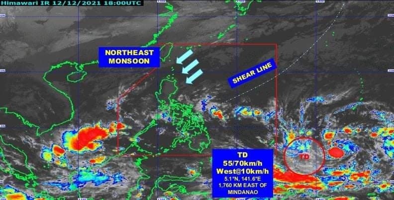
Muling pinaaalalahan ang publiko na maghanda sa epekto ng binabantayang tropical depression sa labas ng bansa na inaasahang papasok ng Philippine Area of Responsibility bukas nang gabi at papangalanang “Odette.”Ayon sa Philippine Atmospheric, Geophysical and Astronomical Services Administration (PAGASA), inaasahang magla-landfall ang bagyong Odette sa bahagi ng Eastern Visayas o Caraga sa Huwebes nang hapon o gabi.Posibleng maging severe tropical storm ang bagyong Odette na maaaring umabot sa typhoon category.Magdadala ito nang malalakas na hangin sa Visayas, malaking bahagi ng Mindanao, at ilang probinsya sa Southern Luzon na makararanas din ng mga pag-ulan.Maaaring umabot hanggang signal no. 3 ang Tropical Cyclone Wind Signal na itataas sa mga lugar na apektado ng bagyo.Dagdag ng PAGASA, posibleng itaas ang signal no. 1 sa bahagi ng Eastern Visayas at Mindanao sa Martes nang hapon o gabi.Pinag-iingat ang mga apektadong lugar sa banta ng pagbaha, pagguho ng lupa, at mga panganib nang malakas na hangin dulot ng bagyo.Inaabisuhan din ang mga mangingisda at sasakyang pandagat na huwag nang pumalaot dahil sa mapanganib na kondisyon ng dagat.Tuloy-tuloy naman ang pag-antabay ng NDRRMC at Regional DRRMCs sa sitwasyon kaugnay ng bagyong Odette.Sa isinagawang pagpupulong ngayong araw, tinalakay ang iba’t ibang paghahanda sa mga apektadong lugar upang masiguro ang kaligtasan ng mga residente at agarang mga aksyon sa epekto ng bagyo.Patuloy na pag-iingat, pag-antabay sa ulat panahon at pagsunod sa mga abiso ng awtoridad ang paalala sa publiko.
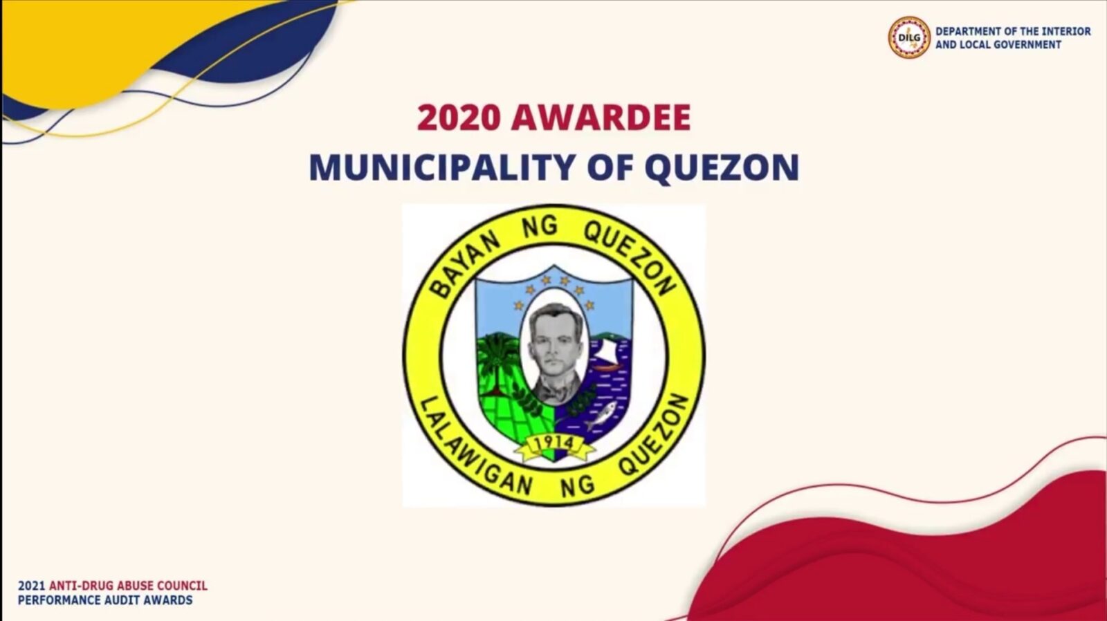
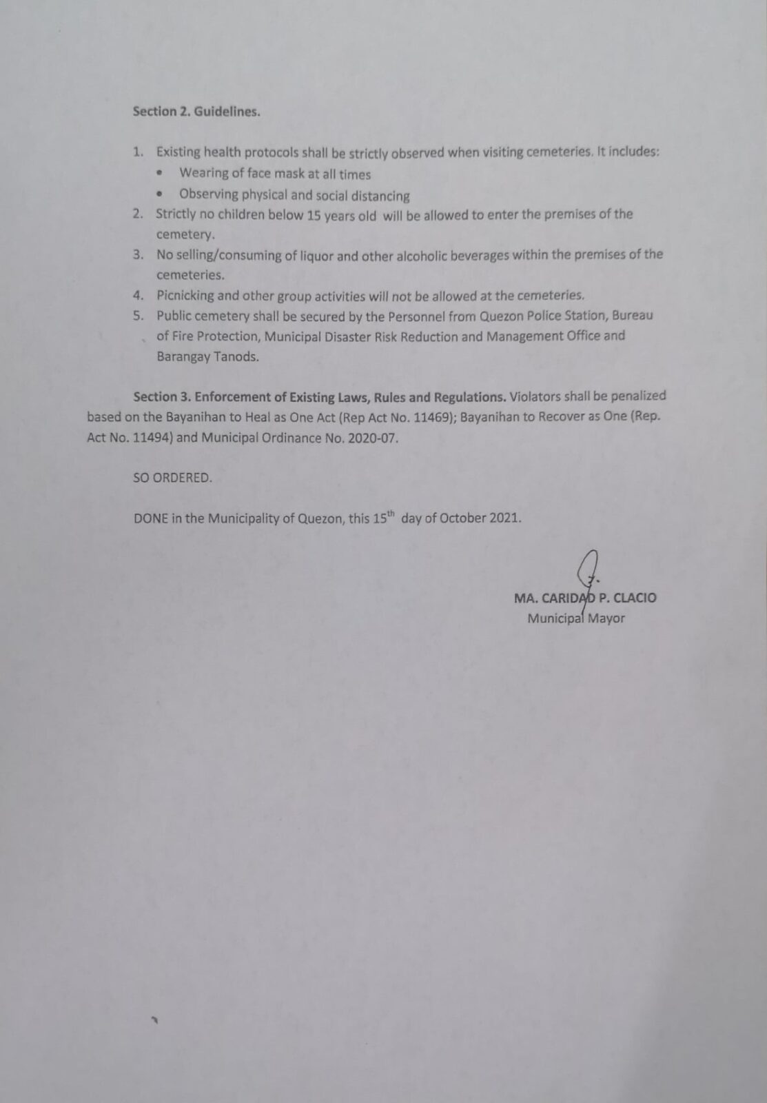
Pagpupugay at pagbati sa Quezon Municipal Anti-Drug Abuse Council sa pangunguna ng ating Punong Bayan Kgg. MA. CARIDAD P. CLACIO at sa Lokal na Pamahalaan ng Quezon, Quezon sa pagiging Awardee ng ating bayan sa ginanap na 2020 ADAC Performance Audit.Maraming salamat sa Department of the Interior and Local Government (DILG), Dangerous Drugs Board (DDB) at Philippine Drug Enforcement Agency (PDEA) sa pagkilala at karangalang ito.
Bilang pag-iingat dahil sa paglakas ng alon tuwing hapon, pansamantalang ililipat ang oras ng byahe ng pampasaherong bangka galing Gumaca patungo ng Quezon.
Ang 1st trip na dating 12:00 PM ay magiging 11:00 AM at ang dating 2nd trip na 4:00 PM ay magiging 3:00 PM.
TROPICAL CYCLONE BULLETIN NO. 1 Tropical Depression “#MaringPH” Issued at 5:00 PM, 07 October 2021 Valid for broadcast until the next bulletin at 11:00 PM today
THE LOW PRESSURE AREA EAST OF CAMARINES NORTE DEVELOPED INTO A TROPICAL DEPRESSION AND WAS NAMED “MARING”.
Location of Center (4:00 PM)The center of Tropical Depression “MARING” was estimated based on all available data at 505 km East of Virac, Catanduanes (13.3°N, 128.9°E) Intensity Maximum sustained winds of 45 km/h near the center, gustiness of up to 55 km/h, and central pressure of 1002 hPa Present Movement South southeastward at 15 km/h Extent of Tropical Cyclone Winds Strong winds or higher extend outwards up to 250 km from the center
TROPICAL CYCLONE WIND SIGNALS IN EFFECT No Tropical Cyclone Wind Signal is currently in effect.
HAZARDS AFFECTING LAND AREAS Heavy Rainfal l• Today, the trough of “MARING” may bring light to moderate with at times heavy rains over Eastern Visayas. • Under these conditions, scattered flooding (including flash floods) and rain-induced landslides are possible especially in areas that are highly or very highly susceptible to these hazard as identified in hazard maps
Severe Winds Current track and intensity forecast shows that there is a moderate to high likelihood that Tropical Cyclone Wind Signals (TCWS) will be hoisted over several provinces in Northern Luzon by Saturday morning or afternoon. The highest possible wind signal for this tropical cyclone is TCWS #2. However, due to the uncertainty in the intensity forecast, there is a possibility that higher TCWS may be raised.
HAZARDS AFFECTING COASTAL WATERS In the next 24 hours, moderate rough seas will prevail over the seaboards of Luzon and the eastern and western seaboards of Visayas and Mindanao. These conditions are risky for those using small seacrafts. Mariners are advised to take precautionary measures when venturing out to sea and, if possible, avoid navigating in these conditions. TRACK AND INTENSITY OUTLOOK • Tropical Depression “MARING” developed from the Low Pressure Area over the Philippine Sea at 2:00 PM today. • On the forecast track, the tropical depression will continue moving generally southeastward slowly in the next 12 hours before turning northward tomorrow afternoon. Afterwards, “MARING” will move north northwestward over the Philippine Sea by Saturday morning, gradually accelerating in the process. By Sunday afternoon, it will move west northwestward towards Extreme Northern Luzon and may pass close or make landfall over Babuyan Islands by Monday. • “MARING” is forecast to remain tropical depression while moving over the Philippine Sea and may intensify into tropical storm by Sunday afternoon.
Considering these developments, the public and disaster risk reduction and management offices concerned are advised to take all necessary measures to protect life and property. Persons living in areas identified to be highly or very highly susceptible to these hazards are advised to follow evacuation and other instructions from local officials. For heavy rainfall warnings, thunderstorm/rainfall advisories, and other severe weather information specific to your area, please monitor products issued by your local PAGASA Regional Services Division.
The next tropical cyclone bulletin will be issued at 11:00 PM today. DOST-PAGASA Link: bit.ly/3eujmdC
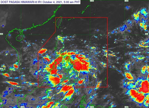
TROPICAL CYCLONE BULLETIN NO. 1Tropical Depression “#LanniePH” Issued at 5:00 AM, 04 October 2021Valid for broadcast until the next bulletin at 8:00 AM today
THE LOW PRESSURE AREA EAST OF SURIGAO DEL NORTE DEVELOPED INTO A TROPICAL DEPRESSION AND WAS NAMED “LANNIE”
Location of Center (4:00 AM) The center of Tropical Depression “LANNIE” was estimated based on all available data at 100 km East of Surigao City, Surigao del Norte (9.8°N, 126.4°E) Intensity Maximum sustained winds of 45 km/h near the center, gustiness of up to 55 km/h, and central pressure of 1002 hPa Present Movement Northwestward at 20 km/h Extent of Tropical Cyclone Winds Strong winds or higher extend outwards up to200 km from the center
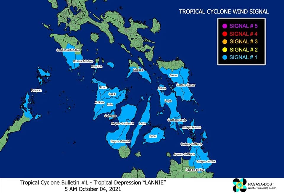
TROPICAL CYCLONE WIND SIGNALS IN EFFECTTCWS No. 1 (Strong winds prevailing or expected within 36 hours) Luzon
The southern portion of Masbate (Pio V. Corpuz, Cataingan, Palanas, Dimasalang, Uson, Mobo, Milagros, Mandaon, Esperanza, Placer, Cawayan, Balud), the southern portion of Romblon (Cajidiocan, San Fernando, Magdiwang, Santa Maria, Odiongan, Alcantara, Ferrol, Looc, Santa Fe, San Jose), the southern portion of Oriental Mindoro (Roxas, Mansalay, Bulalacao, Bongabong), the southern portion of Occidental Mindoro (Sablayan, Calintaan, Rizal, San Jose, Magsaysay), and the northern portion of Palawan (El Nido, Taytay, Dumaran, Araceli) including Calamian and Cuyo Islands. VisayasEastern Samar, Samar, Biliran, Leyte, Southern Leyte, Capiz, Aklan, Antique, Iloilo, Guimaras, Negros Occidental, the northern and central portions of Negros Oriental (Bais City, Mabinay, City of Bayawan, Basay, City of Tanjay, Manjuyod, Bindoy, Ayungon, Tayasan, Jimalalud, La Libertad, City of Guihulngan, Vallehermoso, Canlaon City), Cebu, and Bohol MindanaoSurigao del Norte, Dinagat Islands, the northern portion of Agusan del Norte (Magallanes, Remedios T. Romualdez, City of Cabadbaran, Tubay, Santiago, Jabonga, Kitcharao, Butuan City), the northern portion of Agusan del Sur (Sibagat, City of Bayugan, Prosperidad), and the northern portion of Surigao del Sur (San Miguel, Marihatag, San Agustin, Cagwait, Bayabas, Tago, City of Tandag, Cortes, Lanuza, Carmen, Madrid, Cantilan, Carrascal, Lianga)
HAZARDS AFFECTING LAND AREAS
Heavy Rainfall • Today through tomorrow morning, moderate to heavy with at times intense rains are likely over Visayas, Bicol Region, MIMAROPA, CALABARZON, and Caraga Region. Light to moderate with at times heavy rains are also possible over Metro Manila, Bulacan, Bataan, and the rest of Mindanao. • Under these conditions, scattered flooding (including flash floods) and rain-induced landslides are possible especially in areas that are highly or very highly susceptible to these hazard as identified in hazard mapsSevere Winds • Strong winds (i.e., strong breeze to near gale conditions) with occasional gusts will be experienced within any of the areas where Tropical Cyclone Wind Signal #1 is in effect during the passage of the tropical depression. This may generally cause up to very light damage to structures and vegetation. • An enhanced easterly flow north of the tropical depression may also bring occasionally gusts reaching strong breeze to near gale in strength over Extreme Northern Luzon and the coastal and upland/mountainous areas of the eastern section of Luzon in the next 24 hours.
HAZARDS AFFECTING COASTAL WATERS In the next 24 hours, “LANNIE” will bring moderate to rough seas over the coastal waters of the country, especially in areas where TCWS #1 is in effect. These conditions are risky for those using small seacrafts. Mariners are advised to take precautionary measures when venturing out to sea and, if possible, avoid navigating in these conditions.
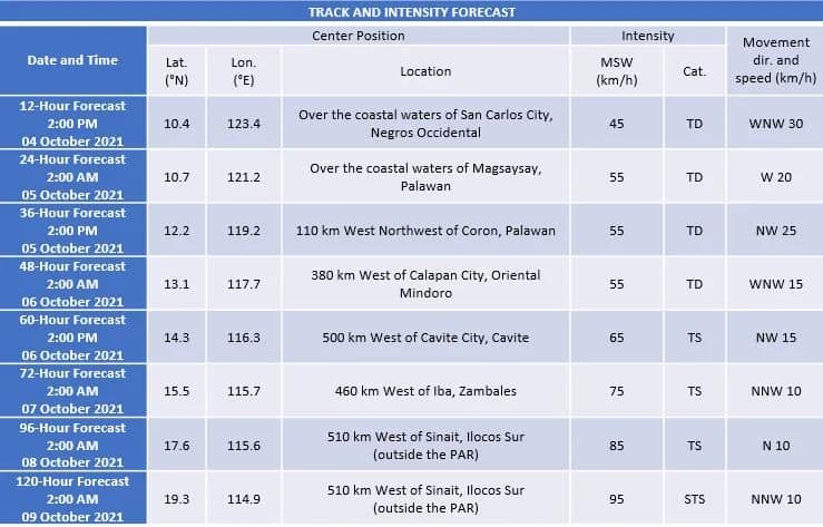
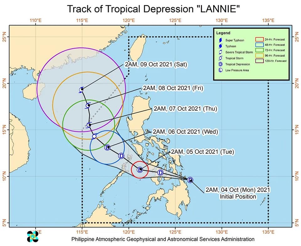
TRACK AND INTENSITY OUTLOOK • On the forecast track, Tropical Depression “LANNIE” may make landfall in the vicinity of Siargao-Bucas Grande Islands in the next 6 hours. Afterwards, the tropical depression will move generally west northwestward and cross Dinagat Islands and Visayas archipelago before emerging over the Sulu Sea tomorrow early morning near or over the Cuyo archipelago. It will then turn northwestward and may pass near or over northern Palawan or Calamian Islands tomorrow morning or early afternoon before emerging over the West Philippine Sea tomorrow late afternoon or evening. Throughout the period of its traverse over the central Philippines, “LANNIE” is forecast to remain as a tropical depression, with a possibility of slight intensification once over the Sulu Sea • After reaching the West Philippine Sea, “LANNIE” will continue moving northwestward until Thursday, when it is forecast turn more north northwestward and decelerate. From Wednesday until the end of the forecast period, “LANNIE” is forecast to intensify. It may reach tropical storm category by Wednesday afternoon and severe tropical storm category by the end of the forecast period.
Considering these developments, the public and disaster risk reduction and management offices concerned are advised to take all necessary measures to protect life and property. Persons living in areas identified to be highly or very highly susceptible to these hazards are advised to follow evacuation and other instructions from local officials. For heavy rainfall warnings, thunderstorm/rainfall advisories, and other severe weather information specific to your area, please monitor products issued by your local PAGASA Regional Services Division.The next tropical cyclone bulletin will be issued at 8:00 AM today.DOST-PAGASA
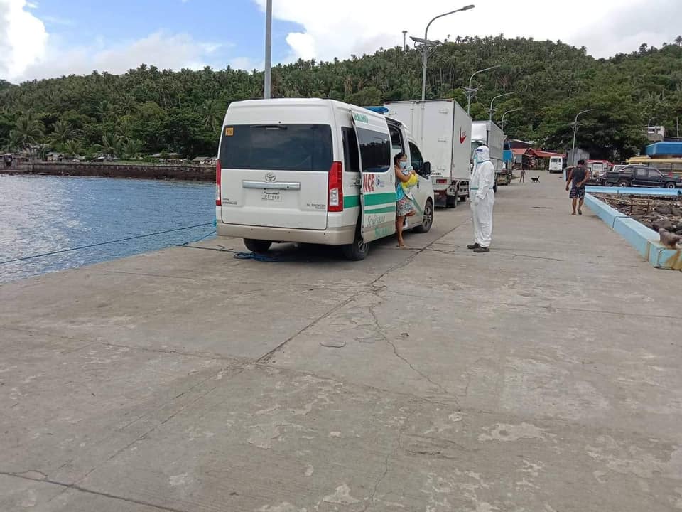
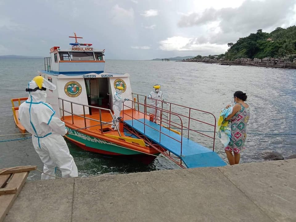
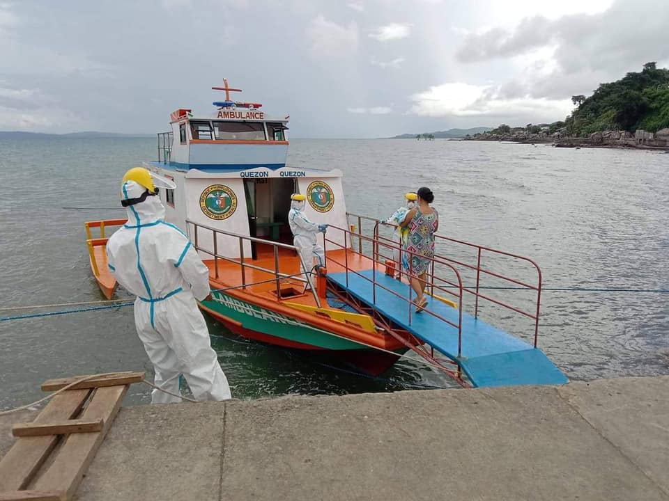
Sa direktiba ng ating Punong Bayan at tagapangulo ng MDRRMC Kgg. MA. CARIDAD P. CLACIO ay patuloy ang pagbibigay ng transportation assistance ng aming tanggapan sa ilang mga pasyenteng nangangailangang ilipat sa mas malaking ospital. Gayundin ang pag-uwi ng mga pasyenteng nagmula naman sa ospital patungo sa ating bayan.
Taos puso po naming ipinararating ang ating pasasalamat sa Quezon PDRRMO na aming katuwang sa pagtulong sa ating mga kababayan.
Hindi po biro ang magkasakit, kaya’t ugaliin po natin ang pagsunod sa Minimum Public Health Standards at makiisa po tayo sa ating ginagawang Vaccination laban sa COVID-19.
Maraming salamat po.
Manage Cookie Consent
We use cookies to optimize our website and our service.
Functional
Always active
The technical storage or access is strictly necessary for the legitimate purpose of enabling the use of a specific service explicitly requested by the subscriber or user, or for the sole purpose of carrying out the transmission of a communication over an electronic communications network.
Preferences
The technical storage or access is necessary for the legitimate purpose of storing preferences that are not requested by the subscriber or user.
Statistics
The technical storage or access that is used exclusively for statistical purposes.The technical storage or access that is used exclusively for anonymous statistical purposes. Without a subpoena, voluntary compliance on the part of your Internet Service Provider, or additional records from a third party, information stored or retrieved for this purpose alone cannot usually be used to identify you.
Marketing
The technical storage or access is required to create user profiles to send advertising, or to track the user on a website or across several websites for similar marketing purposes.