
TROPICAL CYCLONE BULLETIN NO. 1 Tropical Depression “#LanniePH” Issued at 5:00 AM, 04 October 2021
TROPICAL CYCLONE BULLETIN NO. 1Tropical Depression “#LanniePH”
Issued at 5:00 AM, 04 October 2021Valid for broadcast until the next bulletin at 8:00 AM today
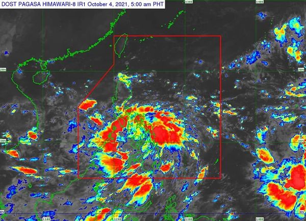
THE LOW PRESSURE AREA EAST OF SURIGAO DEL NORTE DEVELOPED INTO A TROPICAL DEPRESSION AND WAS NAMED “LANNIE”
Location of Center (4:00 AM) The center of Tropical Depression “LANNIE” was estimated based on all available data at 100 km East of Surigao City, Surigao del Norte (9.8°N, 126.4°E) Intensity Maximum sustained winds of 45 km/h near the center, gustiness of up to 55 km/h, and central pressure of 1002 hPa Present Movement Northwestward at 20 km/h Extent of Tropical Cyclone Winds Strong winds or higher extend outwards up to200 km from the center
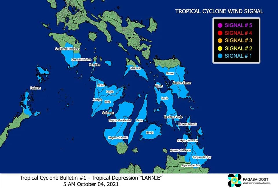
TROPICAL CYCLONE WIND SIGNALS IN EFFECTTCWS No. 1 (Strong winds prevailing or expected within 36 hours) Luzon
The southern portion of Masbate (Pio V. Corpuz, Cataingan, Palanas, Dimasalang, Uson, Mobo, Milagros, Mandaon, Esperanza, Placer, Cawayan, Balud), the southern portion of Romblon (Cajidiocan, San Fernando, Magdiwang, Santa Maria, Odiongan, Alcantara, Ferrol, Looc, Santa Fe, San Jose), the southern portion of Oriental Mindoro (Roxas, Mansalay, Bulalacao, Bongabong), the southern portion of Occidental Mindoro (Sablayan, Calintaan, Rizal, San Jose, Magsaysay), and the northern portion of Palawan (El Nido, Taytay, Dumaran, Araceli) including Calamian and Cuyo Islands. VisayasEastern Samar, Samar, Biliran, Leyte, Southern Leyte, Capiz, Aklan, Antique, Iloilo, Guimaras, Negros Occidental, the northern and central portions of Negros Oriental (Bais City, Mabinay, City of Bayawan, Basay, City of Tanjay, Manjuyod, Bindoy, Ayungon, Tayasan, Jimalalud, La Libertad, City of Guihulngan, Vallehermoso, Canlaon City), Cebu, and Bohol MindanaoSurigao del Norte, Dinagat Islands, the northern portion of Agusan del Norte (Magallanes, Remedios T. Romualdez, City of Cabadbaran, Tubay, Santiago, Jabonga, Kitcharao, Butuan City), the northern portion of Agusan del Sur (Sibagat, City of Bayugan, Prosperidad), and the northern portion of Surigao del Sur (San Miguel, Marihatag, San Agustin, Cagwait, Bayabas, Tago, City of Tandag, Cortes, Lanuza, Carmen, Madrid, Cantilan, Carrascal, Lianga)
HAZARDS AFFECTING LAND AREAS
Heavy Rainfall
• Today through tomorrow morning, moderate to heavy with at times intense rains are likely over Visayas, Bicol Region, MIMAROPA, CALABARZON, and Caraga Region. Light to moderate with at times heavy rains are also possible over Metro Manila, Bulacan, Bataan, and the rest of Mindanao.
• Under these conditions, scattered flooding (including flash floods) and rain-induced landslides are possible especially in areas that are highly or very highly susceptible to these hazard as identified in hazard mapsSevere Winds
• Strong winds (i.e., strong breeze to near gale conditions) with occasional gusts will be experienced within any of the areas where Tropical Cyclone Wind Signal #1 is in effect during the passage of the tropical depression. This may generally cause up to very light damage to structures and vegetation.
• An enhanced easterly flow north of the tropical depression may also bring occasionally gusts reaching strong breeze to near gale in strength over Extreme Northern Luzon and the coastal and upland/mountainous areas of the eastern section of Luzon in the next 24 hours.
HAZARDS AFFECTING COASTAL WATERS
In the next 24 hours, “LANNIE” will bring moderate to rough seas over the coastal waters of the country, especially in areas where TCWS #1 is in effect. These conditions are risky for those using small seacrafts. Mariners are advised to take precautionary measures when venturing out to sea and, if possible, avoid navigating in these conditions.
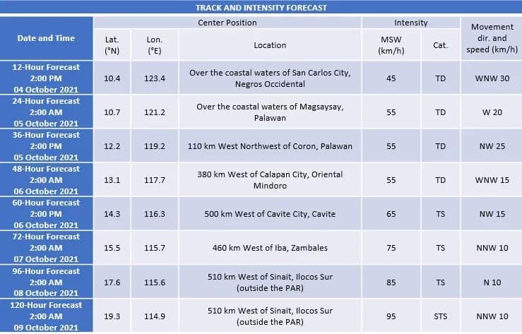
TRACK AND INTENSITY OUTLOOK
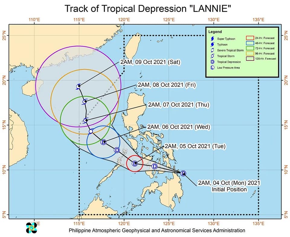
• On the forecast track, Tropical Depression “LANNIE” may make landfall in the vicinity of Siargao-Bucas Grande Islands in the next 6 hours. Afterwards, the tropical depression will move generally west northwestward and cross Dinagat Islands and Visayas archipelago before emerging over the Sulu Sea tomorrow early morning near or over the Cuyo archipelago. It will then turn northwestward and may pass near or over northern Palawan or Calamian Islands tomorrow morning or early afternoon before emerging over the West Philippine Sea tomorrow late afternoon or evening. Throughout the period of its traverse over the central Philippines, “LANNIE” is forecast to remain as a tropical depression, with a possibility of slight intensification once over the Sulu Sea
• After reaching the West Philippine Sea, “LANNIE” will continue moving northwestward until Thursday, when it is forecast turn more north northwestward and decelerate. From Wednesday until the end of the forecast period, “LANNIE” is forecast to intensify. It may reach tropical storm category by Wednesday afternoon and severe tropical storm category by the end of the forecast period.
Considering these developments, the public and disaster risk reduction and management offices concerned are advised to take all necessary measures to protect life and property. Persons living in areas identified to be highly or very highly susceptible to these hazards are advised to follow evacuation and other instructions from local officials. For heavy rainfall warnings, thunderstorm/rainfall advisories, and other severe weather information specific to your area, please monitor products issued by your local PAGASA Regional Services Division.The next tropical cyclone bulletin will be issued at 8:00 AM today.DOST-PAGASA